Quick answer
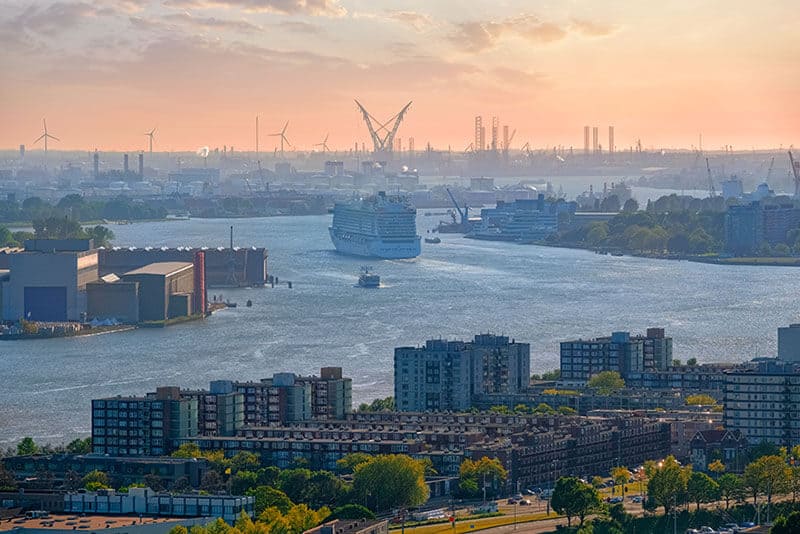
The Nieuwe Maas runs through Rotterdam. This distributary of the Rhine flows west through the city and port before joining the Oude Maas near Vlaardingen. The river divides Rotterdam into northern and southern districts, with the port extending along both banks for over 40 kilometers. The Nieuwe Maas formed in the late medieval period when river engineering redirected Rhine water through this channel.
The Nieuwe Maas carries more commercial tonnage than any other river channel in Europe. The waterway formed when medieval engineers cut channels to drain marshland and improve Rhine delta navigation. By the 16th century, the Nieuwe Maas had become the primary distributary carrying Rhine water to the sea. What river runs through Rotterdam matters because the answer explains the port's geographic advantage. The Nieuwe Maas connects Rhine basin cargo to deep-water berths where ocean vessels can load directly. The river maintains a navigable depth of 12 to 24 meters through continuous dredging. Container terminals, refineries, and chemical facilities line both banks from the city center to the Maeslantkering storm surge barrier near Hoek van Holland. The Port of Rotterdam's visitor center, Portlantis, sits on the Maasvlakte at the river's mouth. The interactive exhibition shows how the waterway system handles 440 million tons of cargo annually. Scale models demonstrate how the delta works as a single hydraulic system, with the Nieuwe Maas as its central artery. Real-time data screens track vessels moving through the channel. The observation deck overlooks the deepwater terminals where post-Panamax container ships berth. Rotterdam's bridges reveal the river's scale. The Erasmusbrug spans 802 meters across the Nieuwe Maas, connecting the city center to the Kop van Zuid district. The De Hef railway bridge, built in 1927, still stands as an industrial monument. Eight tunnel systems run beneath the waterway, including the Maastunnel for vehicles and the metro tunnels that link both banks. The river shaped urban development: northern Rotterdam grew as a merchant district while southern neighborhoods developed around shipyards and docks. The Rotterdam waterway carries Rhine cargo that originates in Switzerland, Germany, France, and Austria. Barges transfer containers from the seaport to inland terminals 900 kilometers upriver. The system moves chemical feedstocks, coal, iron ore, grain, and petroleum products. The Nieuwe Maas functions as both a river and a harbor, with tidal influence extending upstream to the city center.
“The Nieuwe Maas carries more commercial tonnage than any other river channel in Europe.”
What River Runs Through Rotterdam: The Nieuwe Maas Explained
The Nieuwe Maas is the primary waterway defining Rotterdam's geography and its historical development as a global maritime hub. This distributary of the Rhine-Meuse-Scheldt delta serves as the essential artery connecting the city directly to the North Sea.
24 kilometers of river length
The Nieuwe Maas flows for approximately 24 kilometers from the confluence of the Noord and Lek rivers to its mouth at the Scheur.
Nieuwe Maas translation
The name translates literally to New Meuse, though hydrologically it is primarily a distributary of the Rhine.
North Sea connection
The river functions as the vital link between the inland European waterway network and the North Sea, facilitating massive industrial shipping.
Port of Rotterdam identity
The port began along the banks of the Nieuwe Maas before expanding westward toward the sea, shaping the city's maritime industrial landscape.
Tidal influence
As a tidal river, the water level of the Nieuwe Maas fluctuates daily, requiring sophisticated engineering and infrastructure to manage shipping traffic safely.
Erasmus Bridge location
The iconic Erasmus Bridge crosses the Nieuwe Maas, connecting the north and south parts of the city and serving as a prominent architectural landmark.
Portlantis Opening Hours for What River Runs Through Rotterdam Researchers
The Portlantis experience center is open Tuesday through Sunday. It remains closed to visitors every Monday.
| Monday | Closed | |
|---|---|---|
| Tuesday | 10:00–17:00 | |
| Wednesday | 10:00–17:00 | |
| Thursday | 10:00–17:00 | |
| Friday | 10:00–17:00 | |
| Saturday | 10:00–17:00 | |
| Sunday | 10:00–17:00 |
How to Reach the Port of Rotterdam When Asking What River Runs Through Rotterdam
The Portlantis experience center is located at Prinses Máximaweg 301, situated in the Maasvlakte area well west of the Rotterdam city center. Reaching this site requires crossing the port landscape, making private transport or a combination of rail and bus the most reliable methods.
A15 motorway toward Europoort/Maasvlakte
Line B to Hoek van Holland Haven, then connecting bus
Direct via A15 motorway
Best Time to Visit the Port When Researching What River Runs Through Rotterdam
To maximize your experience exploring the history and geography of the New Meuse and the Port of Rotterdam, we recommend an arrival between 10:00–16:00. This window provides sufficient time to engage with the interactive exhibitions before the center closes.
Weekday mornings
Low crowd density—
Visit early to enjoy quieter exhibition halls and more time for research.
April and October
Moderate tourismMild temperatures around 12-16°C
These shoulder months offer comfortable weather for both indoor exhibits and exterior port viewing.
Summer months
High visitor volumeWarm weather averaging 18-22°C
Expect increased foot traffic; arriving promptly at 10:00 is advised to avoid peak midday surges.
Verdict: For the most efficient visit, plan your arrival between 10:00–16:00 on a Tuesday or Wednesday during the shoulder months of April or October.
Check availability
Frequently asked questions about what river runs through rotterdam
Everything you need to know about what river runs through rotterdam